Sunday 26th March 2023
So another season is about to begin, my sixth with Sea Orchid. She is probably in better shape now that she has ever been. Over the winter I have been making the most of the opportunity to utilise some of the local skills here in Tunisia. They are of a high standard and much cheaper than in UK or Europe.
First up, the engine has had a major service. This included a new set of water pump bearings, new thermostat, and repair of a previously undiscovered leak on the heat exchanger.
Secondly, I’ve had a new genoa made, by a Tunisian outfit who are French owned and manufacture the sails for many of the big European boat builders. It certainly looks good and hopefully will give many years of service.
Thirdly, the chart plotter, which succumbed in the thunderstorm when we arrived in Sardinia, has been exchanged for a new one by those splendid people at Garmin marine.
And I’ve had new upholstery made for the main cabin and a set of cockpit cushions.
The jobs list has been well and truly demolished, I’m down at the bottom now with things like re-paint the stripe down the side of the cabin top, and sand out hull scratches ! The prop has been cleaned, the bottom scrubbed, winches and windlass serviced, and the outboard too.
So time to go sailing. If the weather forecast holds then I plan to leave for Malta on Tuesday. It’s 185 miles direct. I was planning to break the passage and go via the island of Lampedusa which is about half way but a little to the south. However the island, which is Italian, is where refugees and immigrants in small boats head for from North Africa, and in the past week there has been a big increase in numbers and many sinkings and deaths. There is a high risk of being approached by a boat seeking assistance but unless they are in immediate danger, ie actually need rescuing, then if you take people on board you are likely to be heavily fined by Italian authorities.
Hopefully the Tunisian Guardia Maritime will let me leave, I have to give them 24 hours notice tomorrow.

Tuesday 28th March
The forecast is for the strong NW wind to slowly abate during the day then swing N and E during the night, and then SE and S during tomorrow. It’s a case of go now or wait another week or so at least. With 185 nm distance to Malta, a little south of east direction, I anticipate 36 to 40 hours passage. I leave the berth at 0900 and head over to the fuel quay. I’m on three quarters full but as diesel is so cheap here (about 80p / lt) I may as well use up all my remaining dinars. Then I’m directed to the Border Police office (immigration) to check out. I have already given them 24 hours notice of departure, but am still sitting there after half an hour while three people are turning the office over seemingly looking for a piece of paper that is not where it should be. The head honcho makes a call, there is much shouting, and then with a smile he says I can go, he gesticulates at the computer which is apparently to blame for the delay. So I say to him sarcastically that computers are always to blame, and then wish I hadn’t as he seems to understand English and not be amused ! Then it’s off to Customs, now this one I am worried about, as I have a new sail which they might try to sting me for some duty, or baksheesh at least. But boat inspection takes just 10 minutes, as I don’t seem to have anything of interest, drones, drugs, guns or stowaways. And then I’m told to leave, immediately, and they mean now ! On the way out of the bay I’m joined by a pod of dolphins, as if saying farewell. Progress is good all day, averaging over 6kts, but with a big sea on the beam it’s wet, very wet. I’m called just once by the Tunisian navy, he asks my destination and it takes me five attempts to get him to understand my pronunciation of Malta, I mean how hard is that !
Later, when I’m north of Lampedusa there is constant calling on Ch16 by the Italian navy, to vessels entering what they have designated as a Danger Area to the south of the island. This is where they are having big problems with migrant boats and they don’t want other boats passing through it for fear of compromising themselves. One ship responded saying that they have no right to prevent vessels entering the area, international law and all that, so I did feel for the poor Italian on the radio just trying to do his job.
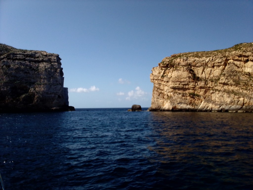
It was a cold night but at least the sun rose early, before 0500. Day 2 was going to be slower as the wind had shifted as forecast. I could no longer lay a course for Malta and speed dropped to 4 kts as the boat slammed into a confused sea. Just a couple of ships crossed my path, heading in the direction of Suez. I decided to motor sail for few hours as I was not keen to spend another night out, and as the promised shift of wind to south did not materialise until I had just 20 nm to go. Landfall was made at 2300 at Dwejra bay, an anchorage with almost 360 degree protection from high cliffs, and a very narrow entrance, made easier to negotiate by the bright moonlight.
Friday 31st March
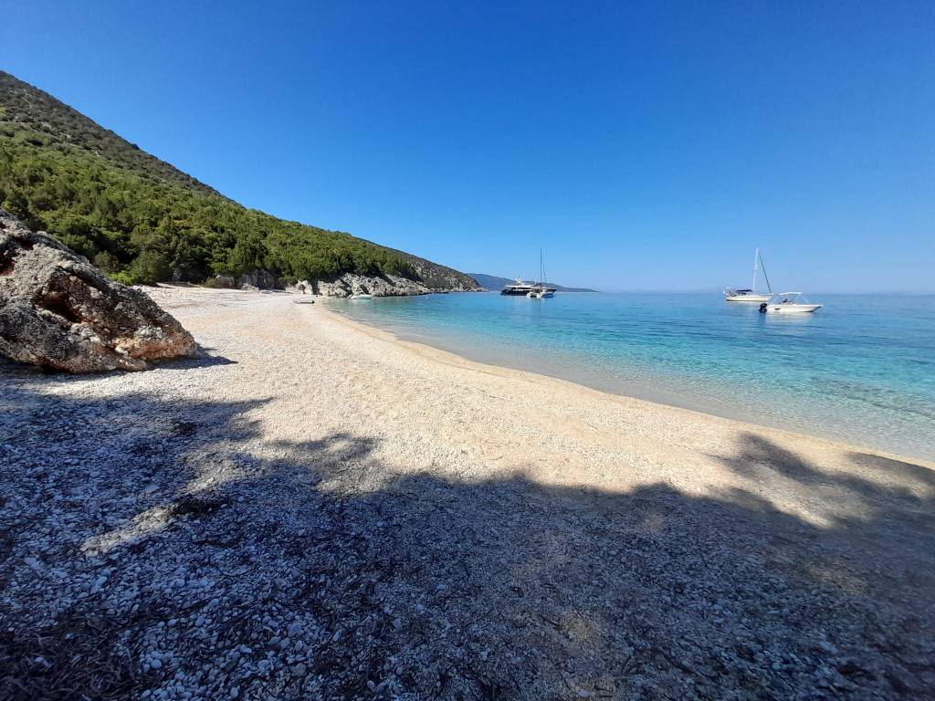
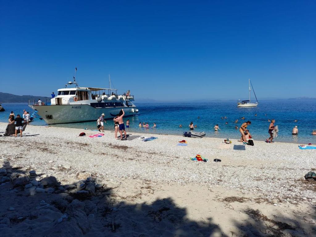
The morning after arriving on Malta I decided I had better clear in with the authorities before going anywhere else. The nearest, and likely easiest to access, would be at Mgarr, the main port on Gozo. The pilot book advised to call the Port Authority before entering and I soon understood why, there were ferries and trip boats streaming in and out every few minutes. I was told to enter after a particularly large ferry but by the time I reached the entrance a fast catamaran ferry had arrived over the horizon doing probably 40kts, so I waved him past. The marina put me on a pontoon immediately below the Border Police and Customs offices so in less than 15 minutes I was all done and dusted. The Police chap puzzled me when he said he couldn’t stamp my passport as he had run out of stamps !!…. and wouldn’t be sent any more until start of April. So he called someone to find out what he should do and was seemingly told to give me a piece of paper saying I had been processed, in case anyone should ask during my stay. The good news is I’m hoping that my Schengen clock has not yet started. I then sailed a short distance to the Blue Lagoon on the island of Comino. Again the Pilot was very accurate with its description of being overrun by trip boats, jet skis, loud ‘bubblegum’ music, and the shore lined with burger vans. But late afternoon they all clear off, so I and one other boat had the beautiful bay to ourselves. The water was indeed very bright turquoise in the sun. I was by now seriously low in the provisioning department, the catering manager having failed to restock adequately in Tunisia. Dinner consisted of two small potatoes, half a can of mixed salad beans and some chickpeas. The last piece of chocolate was savoured for pudding. So the next day I made haste for somewhere with a supermarket. Sometimes luck just doesn’t come your way but on this occasion I did strike lucky. In St Pauls Bay I was making my third attempt to get the anchor to set in a patch of sand amongst all the weed when I guy came over from a nearby boat and said I could use his friends mooring, just behind his own. I always regard such offers with a deal of suspicion, is it really his friend ? does he have a boat that weighs 5 tonnes ? But this guy did seem genuine and his boat reflected an experienced cruiser, so I gratefully accepted the offer. And as luck would have it again, there is a Lidl in town and the bus stop is right next to the dinghy landing stage !!
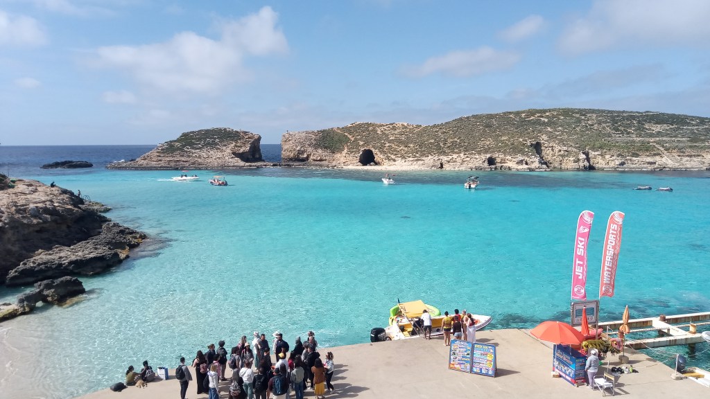
The Blue LagoonOpen
Friday 7th April
After a week of sightseeing on Malta I leave the mooring in St Paul’s bay bound for Sicily. At 0630 precisely I head out to sea and 10 minutes later the sun rises above the horizon just off the starboard bow. There is no wind to speak of but a lumpy sea after many days of strong nor’westerlies. Forecast is for wind to fill from east when a few miles offshore and to slowly swing SE during the day, steady 10 to 12 knots. Indeed as the day unfolds that is precisely what the wind does and I enjoy an easy reach for all of the 60 miles to the very south eastern tip of Sicily. The main occupation soon becomes that of ship avoidance. The channel between Malta and Sicily is too wide to warrant having a TSS, however the number of ships passing through is not a lot less than the straits of Gibraltar, everything heading to and from the eastern Med and Suez Canal. And because there is no TSS it’s not like they are nicely lined up. However I was very pleasantly surprised at how much curtesy I was afforded as a sailing boat. Not only when I was stand on boat did they alter course early, like before 6 miles, but one even altered course approaching from starboard. Unsurprisingly there were lots of gas carriers.
Yesterday I spent a long time on the phone to Garmin tech support as I have been getting occasionally a message appearing on many of the repeater displays saying that GPS remote signal has been lost, and then they go down one by one, and the autopilot bombs. Anyhow I was able to remotely update the software on all but two devices, using their ActiveCaptain app, and today the problem did not arise, so hopefully fixed for good. Also when I was in Valetta, a place where every conceivable marine trade, service and product is available, I was able to obtain a much better anchor, or at least I hope it will be, particularly for getting a good grip in the sea grass. When I anchored in the sandy bay, just around the other side of the south eastern corner, I tried it for the first time. I did the usual revs astern to check it was well dug in and the boat pulled up so abruptly I almost fell over backwards, so that’s a good sign at least.
Monday 10th April
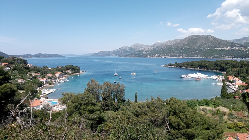
From the anchorage near the village of Torrefiano I commenced the journey north along the east coast of Sicily. With a light south easterly and bright sunshine I set off late morning on Saturday. I shared the water with just a few anglers until a coastguard cutter came up from astern travelling flat out and sped past just a few boat lengths away. His wash caused significant rolling and clattering of sails, and no doubt provided him some entertainment, but entirely inconsiderate. I approached Capo Murro di Porco, which translates loosely to headland shaped like a pig (though frankly I couldn’t see it), it is a nature reserve and I had to pass outside some yellow marker buoys. The wind was by now close astern so I poled out the new genoa for the first time taking great care not to let it flog. It was then a short run into the bay of Syracuse. The pilot suggests calling up Harbour Control for permission to enter but as it was siesta time I received no reply. This was one of the greatest city ports in ancient Greek times and the large, totally protected, bay would have provided sanctuary for fleets of ships. The entrance is dominated by the fortifications built in the 13th century, behind which lies the old town of Ortigia. Boats can moor stern to the town quay in front of the imposing walls but by the time of my arrival it was facing a fair old chop. I was running very low on fresh water so decided to go into the small marina adjacent to the quay. The following day, Easter Sunday, I explored the old town, which being staunchly Roman Catholic, was all turned out for services in the many churches and the Cathedral. I had half expected all the shops to be closed but it was not so as by late morning the streets were filled with tourists. At €55 for the night I didn’t stay in the marina for another, instead going out into the bay to anchor. The bottom is described as soft mud so would be a challenge for the new anchor to hold. At the first attempt it didn’t, dragging under only a few revs, but on the second attempt it held better, though not convincingly. As the wind was light I decided to stay put anyway and see if it settled in with time. This seems to have been the case as today we have had prolonged gusts of up to 30kts. Breaking news on BBC is that a big operation has been underway today to rescue migrants off the coast of south east Sicily. One of the rescue craft is now here in Syracuse.

Sunday 16th April
Yesterday the winds finally looked favourable for the next leg, over to Italy. Along this east coast of Sicily the prevailing NW to W winds are disrupted by the lump of mount Etna standing in their way. But now the wind is from SW and not hindered, once a few miles offshore. The passage to the tip of the big toe of Italy is about 65nm, so a long day stretch and at 0700 I start to weigh anchor. After many days stationary and at times strong winds the anchor is well dug into the mud. The chain brings much of it onto the deck as it comes up, thick sticky black stuff that reminds me of the Dee estuary. As I leave the bay and head north east there are two other boats, catamarans, just ahead. One diverges to east but the other is going the same place as me, and surprisingly doesn’t pull away from me all day. It turns out to be frustrating conditions, the relatively light wind from astern combined with a big swell from the same direction, makes it difficult to keep any pressure in the sails. I try various configurations and resort to the motor when I can no longer put up with the constant slapping of sails. Mount Etna looms on the port beam about 20 miles off, complete with a sugar coating. Cunard’s Queen Vic passes majestically, heading for the Straits of Messina. Slow progress all day means that by sunset I’ve still got a way to go to the only possible anchorage around the toe. It’s completely open to the south, east and west, which is ok from a wind point of view as this settles to the north for the night. The problem is the SW swell directly onto the beach. I lay a kedge anchor out of the stern to try and hold the boat pointing into the swell and stop it laying perpendicular to it, but this proves to be futile in the face of one meter waves. The inevitable rolling is the worst I have ever known, generating considerable stresses on the boat, and which creaks and groans in complaint all night. After a few hours of minimal sleep I can stand it no longer and at first light today I clear out. Today has been a repeat of yesterday, downwind and a big following sea, but it’s only a short distance of 25nm along the coast to Roccella. I have seen a lot of seabirds, which makes a welcome change. They seemed to be parents demonstrating to their adolescent young how to circle a moving boat, passing just inches in front of the forestay. I never tire of watching the way they can manoeuvre like jet fighters, following the contours of the waves. The entrance to Roccella marina faces SW, ie the direction of the swell today, and it is very shallow, so I was glad to get past the sometimes breaking waves and reach the sanctuary of the inner harbour. It’s Sunday so there are no marineros to assist with berthing which, unusually for the Med, is alongside finger berths, as opposed to stern to. The only sign of life is two folks on the Italian flagged boat next to me, and who leap into action upon seeing my imminent arrival.

Mount Etna
Thursday 20th April
From Rocella I crossed the Gulf of Squillace (which does sound very Harry Potterish) to the ancient town of Le Castella. Obviously it’s famous for its castle but it’s also reputedly very close to what was once the island of Ogygia, referred to by Homer in the Odyssey, where the sea nymph Calypso kept Odysseus captive for seven years. Sea level rise since ancient times means that it is now no more, but is evidenced by shallow waters. I arrived in the harbour in dying light and had been unable to raise anyone on the vhf. As I backed onto the quay a gentleman pulled up in a car and took my lines, it seems he has some unofficial role as night watchman. The whole harbour was bathed in light from huge floodlights all night. It is still pre season here and most of the cafes and tourist shops are closed but the castle itself is open, with free entry ! It looks like a film set, standing on its own little island and accessed via a causeway. Later the same day I set off on a beat with about 10kts of wind, the new genoa powering SO along at over 5kts. The 20 mile passage, around three sides of Capo Rizzuto, took me to the town of Crotone just inside the western edge of the Gulf of Taranto. Here I chose to anchor just north of the town and the commercial harbour with its mile long breakwater. Not the most picturesque spot but at least out of the swell and quiet. The next day was an early start at 5am to embark on the 70 nm passage across the Gulf to Leuca, on the very tip of the heel of the boot of Italy. I was keen to arrive before dark so would need to average over 5kts. Winds materialised much as forecast, 10 to 12kts on the port beam for best part of the day, so with relatively flat water SO tore along at 6 kts. And when the wind dropped for periods of time, I added motor power at just 1200 revs which kept the average speed up. I saw just one other boat in the whole day, sailing the reciprocal course, and we met exactly half way across. Not surprising I suppose. On arrival at Santa Maria de Leuca I called up the marina for a berth but was told there was no space, which seemed very odd. But no matter as there was a good anchorage nearby and it was a very still night. This morning as I was having breakfast in the cockpit in the warm sun, the local Guardia patrol boat turned up. They came on board to check papers and ended up staying an hour, filling in forms and stumbling through conversation aided by Google translate. They advised me to avoid the marina and go on the public quay which is free, so that’s exactly what I have done. There are four yachts behind me that have been impounded by the Guardia in recent months, for smuggling drugs and migrants. There is no security so they are being steadily stripped of valuable kit like the winches and electronic instruments. I shall leave some lights on tonight I think !
Le Castella
Friday 28th April
The past few days I’ve been in Otranto, a fine ancient port just around the corner from Santa Maria de Leuca. When I arrived I was hopeful of staying just one night before making the crossing of the Adriatic to either Montenegro or Croatia. It is the only port of entry until Brindisi further up the coast, and a popular place with boats to clear out with customs etc. The plan went to pot when I discovered that the Polizia di Frontera closed at midday on Monday. So I tried again on Tuesday only to discover that it was their Liberation Day, so closed again. So I tried again on Wednesday, office still closed and no contact number or anything. This was getting a little tiresome. So I went to the Guardia Costiera next door where they processed the boat’s departure from Italian waters, but not the passport stamp which has to be the Polizia. However if I go to Croatia instead of Montenegro then I don’t need a passport stamp as they have just joined the Schengen. So that decided it. Unfortunately by then the winds were all wrong, coming down the Adriatic, so I have had to stay another two nights. Two very uncomfortable days and nights, as with a northerly the sea finds its way into the harbour big time. I was very glad therefore to get away this morning even though the light wind is still on the nose and I am having to tack up the coast. It is 150nm to Dubrovnik so not expecting to get there till middle of Saturday night at the current rate of progress.
Sunday 30th April
I arrived at Dubrovnik just after dark yesterday evening. Friday had been a slow day, the wind dying by mid afternoon and having reduced the distance to go from 150nm to just 140nm. During the evening there were a number of ships to negotiate, travelling along the Italian coast. One was approaching very fine off the port bow and rules of the road say that I have right of way. We were still definitely on a collision course at 3nm, closing at 1 nm every 3 minutes. I could have altered course to port but the risk is that at the same time he might do the same and then confusion reigns. So I called him up, he didn’t sound happy, I think he had seen me but hoped I would get out of the way. I asked him to alter course and he asked if I was a fishing boat ! By this time I might as well have been as I was a sitting duck, so he did eventually alter course.
It was a bright moonlit night and very calm. I had to motor till the first signs of daylight when the wind filled from SE, just enough to keep the sails pulling. I saw not a single boat for the entire day but I had a fantastic encounter with porpoises. I was on the foredeck changing the genoa pole over to the other tack, leaning over to release the old sheet, when the first of them reared out of the water not 6 feet away. Gave me quite a fright. Then the rest of the pod appeared darting and weaving across the bow. When I had finished resetting the genoa I stood for 5 minutes at the pulpit while they put on a magnificent display of acrobatics. One literally came up vertically and for a brief second was stood on its tail. They would roll on their side and even right over on their back and keep swimming just in front of the boat. I sang to them which seemed to encourage them more. In the end more and more arrived from astern till there must have been about 20 or so and finally they then raced off.
Boats arriving at Dubrovnic must go straight to the Customs quay to clear in and it operates 24/7. Failure to do this and go for example to an anchorage for the night, will almost certainly result in a hefty fine. I had heard from other cruisers that the folks at this port can be quite corrupt, but usually the trouble arises when trying to leave Croatia when they can make you pay fines for fabricated misdemeanours before giving back your passport. Anyway clearing in proved very quick and within half an hour I was heading back out to the nearby island of Kolocep to anchor.
Friday 5th May
When clearing into Croatia at Dubrovnik I received a vignette, a kind of sailing permit, valid till the end of the year. Leaving behind the bright lights of the harbour I went in search of a suitable anchorage for the first night. I found one just a few miles away at the northern end of the island of Kolocep. In the morning sun, the splendour of the bay was revealed. Very quiet, a dog barking somewhere in the village, and the church bell chimed. I think it must be a Roman Catholic thing as it was the same as in Italy, every so often a bell is rung quite rapidly for about a minute. The small shop didn’t have a great deal apart from lots of apples, they were waiting for the ferry from Dubrovnik to resupply. The following day I took the ferry to the ‘stone city’ as it’s known. It is very impressive with its imposing walls of grey stone, but large parts of it have been rebuilt in the last 25 years following the war with Serbia. An exhibition of black and white photographs taken after bombing, made it look like the streets of Berlin at the end of WW2. Today the streets are packed with tourists.
I was running very low on water. Normally the two tanks last a week each, I was now on day 16, so the next stop needed to have a tap. Unless you go into a marina (for the princely sum of €95 for one night !) then access to water is not easily come by. The Pilot book indicated a tap at the village of Zaton so I headed over the next day. It took a few enquiries to track down Ivan, the man who has the key to unlock the tap. His day job is chef at one of the waterfront restaurants. Unfortunately despite his great efforts to assist me as I brought SO alongside, I managed to fall off the boat and plant my face on the stone quay. It was all rather embarrassing, a guy off the next door super yacht came over with an ice pack and another brought me a stiff drink ! So the price of full water tanks is just €6, a black eye and injured pride.
Kolocep bay, SO in centre.
Saturday 6th May
The winds along this stretch of coast are very localised. I use the PredictWind app, their PWG 8km model, which I have found to generally be the nearest to reality. Wind bends around island, funnel between mountains, and align with channels. There are potential destinations in many directions so I’m tending to decide the next passage on the day. Yesterday I went from the mainland harbour at Slano, west to more open sea amongst the islands, in the hope of finding more wind. By mid afternoon I was bashing into 18kts tacking my way up a 4 mile wide channel. Not quite what I had in mind, but I was confident that the destination would make it worth the effort.
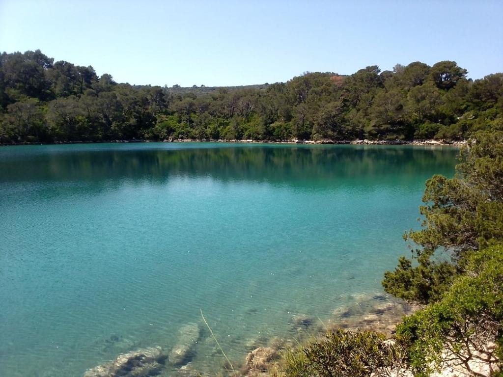
If you can imagine complete silence and stillness then this is how it was last evening in the anchorage on the island of Mljet. I was inside the National Park and nature reserve, the first such designated in the whole Mediterranean, back in 1960 (a fine year if I may say so). I have not experienced such a peaceful setting since visiting islands on the west coast of Scotland. Here the steep hillsides are heavily wooded, bare limestone rock exposed in a ribbon along the waters edge and in patches on the peeks. If you walk the trails that lead inland you reach the lakes, where the water is blue green. There are a few old stone cottages along the waters edge, mostly seem to be holiday let’s. A once monastery stands on an island in one lake. A Roman built his palace here in the 3rd century AD.
Apologies to the king for missing his big day but I am very glad I did not miss this place.

Monday 8th May
It was a short sail from Mljet, north to the Peljesac peninsular and the secluded bay of Uvala Vucine. I then headed west to the island of Badija, just off the eastern end of Korcula. This was another stunning setting, with the Franciscan Monastery standing resplendent by the waters edge, and the mountains as a backdrop. It is a functioning monastery although in the ‘50s under communist rule it was confiscated and turned into a sports facility. The grounds still display the remnants of soviet era facilities. In season this anchorage is packed and they charge €30 for the privilege, but last night there were just two of us and no one turned up to collect a fee. Today however I anchored in a bay just outside the old town of Korcula and the man turned up at about 5pm to collect the fee so I said I would not stay but would move on instead. It has been very convenient though for a trip to the supermarket, just 5 minutes walk from where I could leave the tender. The town itself is like a miniature Dubrovnik, surrounded on three sides by water and imposing walls that enclose the steep narrow alleyways. It’s claim to fame is that it is reputed to be the birthplace of Marco Polo. Can’t imagine anyone wishing to leave this idyllic place today to go and live in China!
I have now moved on just a couple of miles to an anchorage at Uvala Banja. It’s another very sheltered spot, which is just as well as for the next few days strong winds and heavy rain are forecast.

Friday 12th May
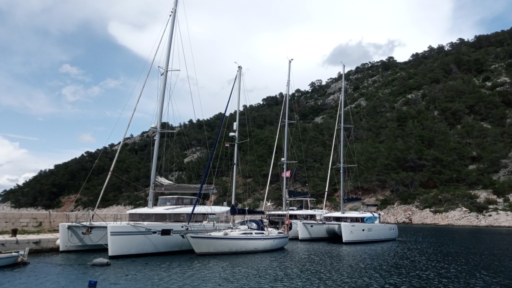
From Uvala Banja I continued the journey northward through the islands. I left intending to get to the island of Hvar but, has so often happened, the promised wind did not materialise. So as I passed the small island of Scedro I decided to pull into a small secluded anchorage. It was late afternoon when boats that have come out for the day tend to up anchor and head back to base, and the night shift, like myself, move in. There was one very large super yacht in the centre of the bay and I could see they were preparing to leave so I only had to hang about for a few minutes before taking their spot. The following morning I paddled ashore for a swim and walk, but the walk was a non starter for the undergrowth was so dense from the back of the beach. When the wind filled I set off again for the western end of Hvar. Passing through the narrow channel between the Pakleni Islands and the old town of Hvar. I could see a cruise ship and many super yachts moored in the harbour. The Pilot book warns that there is little chance of finding a free space and anchoring is not allowed. So I continued onward a few more miles around the western tip and back along the north coast where there are numerous bays, though some too deep and steep sided for anchoring. I ended up in Uvala Sviracina, which has one house and a small beach at its head. Taking care to drop the hook on a patch of sand and not weed and with 50m of chain in 10m depth, I was well secure for the night with 20kt gusts. Very strong winds are forecast for the next few days so I wanted to find good shelter. The nearest town is Stari Grad which has a quay but before that there is a bay which uniquely has a small quay which is free to use and is not occupied by loads of local fishing boats. It is just big enough for two boats alongside, and there were already two there when I arrived, so it was going to be a case of rafting up. The crew of a 45ft Lagoon cat with Australian flag were more than happy for me to go alongside them, SO is dwarfed by Cape, so named after her owners, Carol and Pete.
Friday 19th May
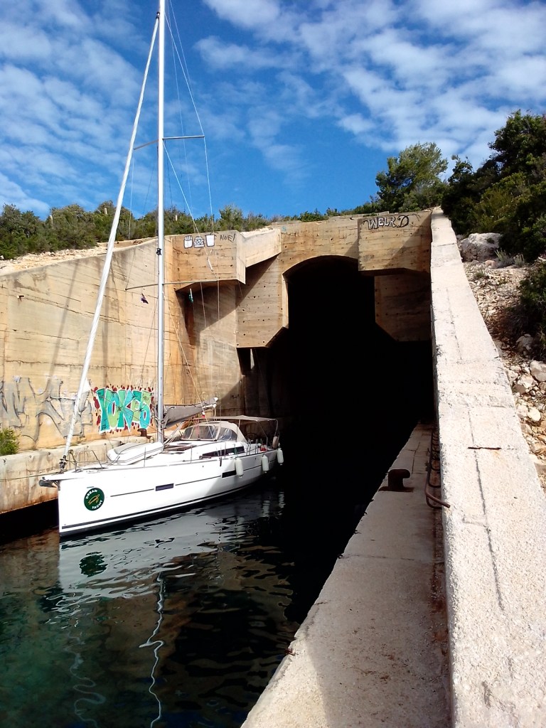
So after a number of days hunkered down on the quay the weather has finally started to pick up. It had rained almost continuously for 4 days, and winds out in the open sea reached 50 kts, but in this bay it was much less and my berth alongside the catamaran proved very secure. I did manage to hitch hike to Hvar, which has a very beautiful harbour. And on Monday the winds died away for a few hours so I had a ride with my neighbours on their cat, a few miles down the coast to Stari Grad. Just a half mile before the town quay there is an anchorage next to a ferry terminal behind which is a hypermarket. It’s the most convenient place to do a big shopping run and stock up. On Wednesday afternoon I set off to the island of Vis, about 15nm distant to the west. The wind was still blowing 20kt from SE so it was a fast passage, frequently hitting over 7.5kts surfing off waves. I went into the anchorage at Uvala Parja just around the corner from the harbour of Vis town. The bay is famous for the submarine pen that was part of Tito’s naval base on the island. Totally camouflaged from the air but unmissable from the boat. Inside it’s like a James Bond movie set. As you can see in the photo some boats moor up at the entrance. If there hadn’t been a boat already in the way I’m pretty sure SO would have fitted right inside with her short mast. The waterfront of Vis town is another beauty, with almost no modern development as the island was only opened to visitors in the early 90s. Today I started to head back south again having gone as far up the Croatian coast as I had planned. It started well with a beat into 14kts but by mid morning it petered out and with a very lumpy sea I was making no progress. So I changed course and headed east to the Pakleni Islands just offshore from Hvar. There are many places to anchor here although there are a lot of tour boats in the day. Tomorrow is forecast for 15kts again so hopefully better progress south will be made.
Sunday 21st May
Well so much for the promised 15kts of wind in the forecast on Friday. By yesterday morning it had all but disappeared. I am keen to keep making some progress southward but without having to motor, so I set my sights again on the western end of Korkula. I managed to sail two thirds of it but gave up in the end and motored round to the southern side and a secluded bay, Uvala Slatina. The bottom is pure sand and in the sun it reflects a brilliant turquoise. I briefly explored the beach at the head of the bay, there are a few very swish holiday homes scattered amongst the trees. However they don’t seem to take much care of their environment, the plastic rubbish piled up on the beach is some of the worst I’ve seen. Today the forecast again has little wind in it, so I set my sights for the next stop at just 9 miles along the coast, to Prizba Mali. There are numerous little islets along this stretch, providing great shelter and flat water inshore. This make it feasible to achieve an average 1.5kts in just 4kts of wind. I’ve anchored on the east side of the spit in 6m over sand. There is a small shop in the village so hopefully I will be able to do some foraging in the morning. No point in rushing off again anyway, there’s no wind in forecast !

Wednesday 24th May
The shop in Prizba Mali was disappointing, I only bought some apples. It was another windless start to the day so I set off with no particular destination in mind. The south coast of Korkula is endowed with many coves, we will see how far we can get and pull in when there is no merit in persevering. As it happened, and contrary to ALL five of the weather forecast models that I refer to, the wind steadily increased from astern reaching 14kts by late afternoon. Consequently I managed to do a record 18nm for the past week. Uvala Przina, at the very eastern tip of the island, is a wide bay with a sandy beach, that had many visitors when I arrived. The summer season seems to be getting underway here now. Certainly the number of boats out and about every day is far more than it was three weeks ago. Catamarans outnumber monohulls, and all are outnumbered by the trip boats during the day. But at night I had the anchorage to myself, just the sound of the church clock striking in Lumbarda. Next day it was again a windless start but I’ve now got a hang of the pattern and set off confident wind will fill in from around midday. It will need to as there is nowhere to stop this time till I get to Uvala Prapratna, 23nm away. True to form the wind did eventually arrive and I just managed to make it by 6pm when it died away completely again. Today was the final leg of my whistle stop tour of southern Croatia. It finished with a fine beat in 10kts over flat water, and I left it in the hands of the autopilot which I have to confess can do a better job than me in such conditions, when set on ‘Hold Apparent Wind Angle’. Tonight I’m in the bay at Lopud, listening to live music wafting over the water from a nearby hotel veranda. It has just been interrupted by someone letting off old flares, two red hand helds, and a red parachute. Not clever.
Friday 26th May
Left the anchorage on Lopud yesterday at 0600 in order to be at the customs dock at Dubrovnik early and hopefully be able to clear out of Croatia without too much delay. As I approached the harbour at 0730 a cruise ship was docking and another was already docked. Dozens of coaches were ferrying passengers along the quay to the customs block. As I moored up, the line of people out of the door was extending by the minute. So I sought a police official for assistance and he was most helpful shepherding me past the queues to alternative offices to be processed. I was worried that I would fall foul of some paperwork requirement and a corrupt official would fine me, like so many cruisers that I’ve heard about. But nothing of the sort happened and I got my passport stamped so that the Schengen clock was stopped. Once cleared out it is important not to stop again on Croatian territory, and it is 30nm to the border with Montenegro. The forecast yet again was for light airs but with the promise of some following wind in the afternoon. Indeed after a few hours motoring I was able to sail and by mid afternoon was bowling along at 5kts. Thunderstorms approached from the mountains but I managed to dodge them. The Gulf of Kotor is made up of three large basins surrounded by steep mountains up to 1000m. It reminds me of lake Garda. The mountains generate katabatic winds so that most anchorages can be affected by violent gusts. However I spent the first night in Porto Montenegro as clearing in through customs etc is assisted by marina staff. I was glad of the assistance as it proved to be a complicated affair visiting four different offices and shuttling back and forth, taking nearly an hour in all. The marina serves the largest super yachts, and was a refuge last year for Russian oligarchs who were seeing their boats impounded in all EU countries. This morning was a chance to do chores before having to exit the marina by midday. Laundry, supermarket run, purchase of local SIM card, rubbish disposal, fill up with water and diesel (half the price of the last fill in Italy). Tonight I’m anchored off the village of Risan which has been a settlement for 6000 years at least. I went to visit a Roman villa and it’s mosaics, including one showing a reclining Hypnos, god of sleep. There are katabatic gusts in the high twenties at present, some Hypnos power will be handy tonight.
Monday 29th May
It was a fretful Friday night on the anchor at Risan with katabatic gusts up to 30kts but the bottom was clay which made excellent holding, even if it did make for a messy deck the next morning. The wind remained light and fluky all day, apparently normal for the Gulf in summer. But I managed to sail very slowly into the north eastern basin to the UNESCO heritage town of Kotor at its head. A cruise liner anchored in the middle of the bay towered over the old city walls. The narrow streets were packed but in the Maritime Museum there were just a few others. The towns around the Gulf have been a major supplier of seafarers to other Mediterranean counties over the centuries. At Perast there was a naval school established in the 16th century where rulers from as far away as Russia sent their aspiring officers. Montenegro is growing a modern high standard tourist industry, restoring the fine medieval stone buildings, alongside new architecture. There are also many abandoned old buildings, including some churches, and in amongst it all there are decaying concrete monstrosities from the communist era. Last night I was anchored off the southern side of the island of Sveti Marco, which was a communist era holiday camp, and now all lies abandoned, nature reclaiming as it does. Today I sailed out of the Gulf to continue the journey south. On the way out I encountered another cruise ship coming in and we met at the very narrowest point. I was beating into a F4 and so entertained the passengers on deck with some short tacking to get by. I also passed the island of Mamula guarding the entrance to the Gulf, with its WWII prison which was notorious for where Mussolini incarcerated and tortured local resistance fighters. It has just opened as a luxury hotel much to the anger of locals who, understandably, would rather it have become a museum and memorial. It has been quite refreshing to be back out on open sea again, after the stifling feel of the Gulf with its windless flat water and towering mountains. Tonight I’m anchored in a remote bay called Dobra Luka.
Wednesday 31st May
Heading south, and before reaching the port of Bar, to clear out of Montenegro, there is the town of Budva where I was hoping to spend a night. However, as has often been the case along this coast, the Pilot book is out of date when it comes to the realities of being able to anchor. I use Navily, a website where cruisers record their experience of an anchorage, for the most recent reports. Here the reality is that anchoring is either forbidden officially, or discouraged by locals who use the space for private moorings, and the marina that want to force you into their den. The wind was light but enough to keep up 2 to 3 knots average so I carried on south to a splendid anchorage at Uvala Maljevic, just across the bay from Bar.
The following day was an early start, across the bay into Bar harbour to clear out. There was no response from the harbour master on Ch16 so I proceeded into what is Montenegro’s main commercial port. Apart from a cruise liner and one ship loading stone from a nearby quarry, the wharfs were deserted. I made my way to the inner basin to the customs quay, and moored amongst the police and military vessels. It was then a case of hunt down the harbourmasters office, which I was told by the police is housed in a grey building in the centre of town. Here all the buildings are shades of grey ! Eventually all forms have been filled and passport stamped and I was free to leave, and incidentally, not stop again. It was for the most part a fine sail down the coast on a dead run 20 miles to the Albanian border where the river Bojama or Bunes, meets the sea. Here the mountains have given way to a flat delta lined with beaches which look more muddy colour than sand. Remnants of past beach side bars are strewn along miles of deserted coastline. The usual afternoon thunderstorms were brewing over the mountains, a few miles inland, as I approached the Albanian port of entry, Shengjin, (not to be confused with the town of Schengen and it’s infamous border treaty). First impressions from a distance are of a seaside resort similar to any other around the Med with modern apartment and hotel blocks. Closer inspection reveals a run down and neglected harbour where there is much dereliction and many rusting hulks. However I receive a very warm welcome from the Port Authority who call me up as I approach. I am directed to moor at an old quay where Mr Frock the agent is awaiting my arrival. You still have to engage an agent, an archaic practice dating from a time when only commercial ships came here. Most of the coast of Albania was mined by the dictator Hoxha, and these were only cleared in the 1990s. Even today there are areas where it is unwise to anchor. Shengjin was a naval base and remnants from this time lie all around. Mr Frock tells me he was in the navy, now he earns a small fee handling the clearing of just a few boats that call here. Most don’t and go instead to the city of Durres, another 35 miles further south. He was most adamant that when I want to leave I must call him as he has to give me a piece of paper, to show authorities if stopped, that I have officially entered the country. There is no facility to stamp the passport. He cannot give me said piece of paper though until I am about to leave as he has to witness my departure !
Saturday 3rd June
I left Shengjin Thursday morning as soon as I had been handed the important piece of paper by Mr Frock. Forecast was the same as every day for the past 10 days, very little in the morning slowly filling in from NW around midday and building to maybe 10 to 12 kts by late afternoon before fading away. It did exactly that and I was able to make it to Durres by early evening. This is Albania’s major port, with one small quay in a corner for non commercial boats. However I anchored outside the harbour close to the eastern breakwater along with one other boat. I took the dinghy into the port, a long ride past derelict buildings and rusting hulks, and headed for the small boats in the corner. A lady came to the quayside as I approached so I was worried I was going to be turned away. Quite the contrary though, she was so obliging, yes I could park my dinghy no problem, would I like to use their WiFi !! The next day I repeated the dinghy journey and walked into the city. The lady warned me it was not an easy route to walk even though less than a mile but it meant negotiating a way around the secure ferry port and crossing a major road system. Fortunately it seemed that locals took the same route so I followed the crowd, squeezed onto a narrow strip of road between a high fence and oncoming traffic. The city centre is as cosmopolitan as any other and has preserved just a couple of its historic sites, including a Roman amphitheatre, the largest built outside of Italy. Again I’m struck by how friendly the Albanians are, and the young generation want to speak English. Lunch of pizza and coffee costs a whopping 280 leke, about £2.50 !
I left Shengjin Thursday morning as soon as I had been handed the important piece of paper by Mr Frock. Forecast was the same as every day for the past 10 days, very little in the morning slowly filling in from NW around midday and building to maybe 10 to 12 kts by late afternoon before fading away. It did exactly that and I was able to make it to Durres by early evening. This is Albania’s major port, with one small quay in a corner for non commercial boats. However I anchored outside the harbour close to the eastern breakwater along with one other boat. I took the dinghy into the port, a long ride past derelict buildings and rusting hulks, and headed for the small boats in the corner. A lady came to the quayside as I approached so I was worried I was going to be turned away. Quite the contrary though, she was so obliging, yes I could park my dinghy no problem, would I like to use their WiFi !! The next day I repeated the dinghy journey and walked into the city. The lady warned me it was not an easy route to walk even though less than a mile but it meant negotiating a way around the secure ferry port and crossing a major road system. Fortunately it seemed that locals took the same route so I followed the crowd, squeezed onto a narrow strip of road between a high fence and oncoming traffic. The city centre is as cosmopolitan as any other and has preserved just a couple of its historic sites, including a Roman amphitheatre, the largest built outside of Italy. Again I’m struck by how friendly the Albanians are, and the young generation want to speak English. Lunch of pizza and coffee costs a whopping 280 leke, about £2.50 !
Durres, confidently looking to the future
Wednesday 7th June
Sunday morning I was waiting for a little breeze to take me down the Gulf of Vlore to Orikum at it’s head. Quite suddenly the wind filled in and by the time I had the anchor up it was blowing 14kts through the gap between Sazan island and the Karaburun peninsular. I tore across the gap on a beam reach with wind touching 19kts and with no reef in. Then as soon as behind the mountain ridge it went to nothing in less than a minute. As I approached the head of the gulf it filled in again to 15kts and now from an angle that was just along shore. It was clear that the anchorage outside the marina, that I had hoped to use, was not now going to be tenable. So I went into the marina, the approach is a dog leg between port hand markers and a breakwater, it is prone to silting and mid channel I went down to half a meter under the keel. They get few visitors here as it is well off the beaten track. It’s a quiet dusty backwater, imagine tumble weed rolling across the flat landscape, with a backdrop of mountains. It’s the only marina in all of Albania but I have seen billboards with artist impressions of new marinas for Durres and Vlore.
After a day sightseeing inland visiting the 6th century BC Site of the city of Appoloni and the Ottoman town of Berat, I continued the journey south. First though its 10 nm back north to exit the Gulf. Then a similar distance down the outside of the peninsular, to a remote inlet, Orso bay, tucked into the mountains. I took a stern line ashore on the north side because there is a good chance of katabatic winds in the night. The surface of the rocks is pitted like a giant rasp, that could saw through rope in no time. So I used chain for looping around a rock.
This morning whilst it was sheltered in the bay it was anything but outside. For the first few miles the wind came down off the mountainside, reaching 30kts. SO was doing hull speed on flat water, about 8kts, on a broad reach. I had one reef in and wished I had two. And then it suddenly stopped, you could see a line on the water as if drawn by a large hand, one side furious wind, the other nothing. Tonight I’m in a wide sandy bay backed by the resort town of Himare. I can see Corfu about 20 miles away. But first I have to go to Sarande to clear out of Albania.
Apollonian
Sunday 11th June
Albania, a country of contrasts is how I would sum it up. Modern shiny resorts being built alongside crumbling Cold War bunkers and machine gun placements dotted everywhere. Little remains of the old stone medieval towns, at least on the coast, unlike Montenegro next door which is stuffed with them. But plenty of communist era apartment blocks in concrete. Fabulous and well preserved remains of ancient cities, with much still to be uncovered. Ancient tractors in the fields, and the latest German premium brand cars and electric scooters in the towns. Modern industrial units stand next to decaying and abandoned ones. The people are more friendly than any other country I’ve been to recently. They want to speak English and ask what you think of their country. Their seems to be an economic boom but the roads and infrastructure are lagging behind private enterprise. There is poverty with people begging in the streets, but the majority seem happy and optimistic, so why are many trying to migrate to UK ?
After a trip to the ancient city of Butrint and a journey up into the mountains yesterday, today I checked out with the able assistance of my agent Jelija. She efficiently processed all paperwork and arranged for two gas bottles to be refilled for the grand sum of €6 ! It is a mere 15nm from Sarande to Corfu town where I would need to clear into Greece and Schengen. The border runs down the centre of the channel between Corfu island and the mainland and is just 1 mile wide at its narrowest. I wasn’t sure when best to drop the Albanian flag and hoist the Greek one along with the yellow Q flag, but don’t suppose anyone cared. I anchored just west of the ferry and cruise liner port, it’s the nearest you can get to the Customs and Port Police. It took two hours to get past Customs, Immigration and Police, and I felt like they really didn’t want to let me in at all. I was issued with a Transit Log valid for 6 months which I have to get stamped both in and out of every place I go where there are Port Police, goodness knows why.

Fish traps at Butrint. They’ve been fishing exactly like this here for 3000 years
Thursday 15th June
On Tuesday morning everything (clearing in, shopping and weather) has finally come together to enable a departure from Corfu. A light breeze from SE is just enough to get away from the shadow of three cruise ships. The town will be packed today. I round the top of Nsis Vido close hauled into 4 to 5 kts. A rainstorm is brewing over the mountains behind me and I’m trying to make out which way it’s moving. Normally I use a rain radar app but weirdly many don’t cover this region or if they do they are not showing anything. As I sail south I stay in clear skies, destination undecided. Initially between Corfu island and the mainland coast, there is a choice of anchoring on the Corfu side in one of many sandy bays but competing for a space amongst dozens of others, or anchoring over on the mainland side in a quiet secluded bay, where it will be muddy and mosquito infested. A difficult choice. So I press on till the land on the mainland side starts to rise and I find a secluded bay with sandy bottom. It’s on the northern side of the approach to Igoumenitsa. The only downside is the wash from passing ferries, at least a mile away but wash carries a long way and sometimes builds energy as it travels. In the morning it’s a paradise and I do some snorkelling amongst the rocks, spotting a few small flat blue fish and lots of silver ones. Then a tour boat appears round the corner, I can hear him long before seeing him, so I make a rapid exit. Travelling across the narrow buoyed entrance to Igoumenitsa I carry on into the bay with the village of Platarias at its head. I anchor in front of the beach but the wind decides to blow straight into the bay and builds to a F4, so it’s a bumpy dinghy ride into the small harbour. By nightfall there are a dozen boats anchored around me, and this morning there was a mass exodus, most are charter boats heading back towards Gouvia marina for Saturday changeover I dare say. Lots of wind is promised from south today but as I head out of the bay and turn toward the islands off Mourtos, it dies completely. There are many potential anchorages amongst these islands but some are rammed. Eventually I find a spot in shallow water in a bay on the west side of Nikolaos island, already occupied by three others. I take a line ashore as there is very little room to swing. Later another boat comes in and tries to do likewise but he is clearly inexperienced and seems to have a novice crew. There is lots of shouting as he crashes into another boat and has two further attempts before finally getting into a good position an hour later. I do feel for him and his embarrassment, but it did make for good entertainment for the rest of us !

Before the tour boat arrive
Sunday 18th June
After leaving the anchorage on Nikolaos island and rounding the top of Syvota island I could see the northern end of the island of Lefkada, my final destination of this cruise. Winds were set to reach F5 from NW later in the afternoon so I aimed for one of a few possible anchorages around Parga, which should be in the lee. As I pulled into the main bay at Parga itself the wind bent around the corner, some 90 degrees, so giving no lee at all. I tried the next bay, the other side of a high rocky outcrop with a fine Venetian Castle atop. There was some shelter there but it had already been grabbed by two superyachts, so I moved on again to the next bay at Lychnos. Third time lucky and I drop anchor on the western side keeping 200m off the beach, where hundreds of sun beds are lined up in neat rows right down to the waters edge. The following day I take full advantage of the brisk NW wind to do 30nm to the Lefkas canal. It’s a fine broad reach but the sea has built up over the last few days from persistent strong NW winds further offshore. As I approach the canal entrance I’ve got 3m+ waves on the quarter, some breaking, and the wind touches 20kts dead astern. It’s a lee shore shallowing to 7m, the breakwater is only 200m off the beach and will not provide any protection until inside. So it means having to bring the boat round 180 degrees to get the mainsail down before heading in. This calls for careful timing of the turn so as not to be broadside to a breaking or steep wave. SO handles it well bucking and kicking while I’m on deck getting the main down in short measure, the only hitch being a loose strap on the back of the cockpit hood which tangles in the main sheet. Inside the very small harbour there are four of us waiting for the next bridge opening which is on the hour, 40 minutes to go. We all have to gig around each other in the tight space. As we pass Lefkas marina, half way down the 3nm canal, dozens of charter boats come pouring out like traffic joining a motorway from a service station. At the southern end of the canal on the western side is a shallow bay and large anchorage where I pull in for the night. Today it was a short downwind sail to Vliho Bay, my final destination of this cruise. A procession of boats come streaming out of the canal and disperse to the many islands to the south. The entrance to Vliho bay is a narrow channel with the town of Nidri on the western shore, lined with quays and jetties festooned with boats. The channel itself is clogged with boats at anchor, so dense there is no clear route through. Last time I was here, more than 10 years ago, there were many boats anchored around the edges of this bay, which is about a half mile across and a mile deep. Now it is full of anchored boats, one side to the other, top to bottom. I fear this part of the Ionian, which was always a very popular cruising destination, has fallen victim to its own success.
Tomorrow SO will be hauled out for a couple of months well earned rest. I hope to return in September for the second half of this years adventures.
2nd September 2023
Back on board and glad to find SO exactly as she was left 2 months ago. The following day and a half were busy preparing the hull and then antifouling. The temperature in the day was over 30 so the first coat was done early evening and the second early morning. Also fItted a new prop anode, the main hull anode has another season in it. Re-launch was as smooth as the lift out, very impressed by the hydraulic trailer and much less faff than a travel hoist. Once afloat we filled up with water, fresh water tanks I mean ! Then we motored a short distance down Vliho bay to anchor off the yacht club. The club serves good food at reasonable prices, and the fish and chips were great. Amanda made use of their showers, possibly the last chance for a while. It was a still night but the road along the shore delivers noise across the water.
Today we set sail out of the bay, following a procession of boats, mostly Sunsail charters, through the channel past Nidri. Then set a course south of Skorpios and over to the east side of Meganisi where there are numerous anchorages to choose from. However the number of boats are even more numerous so it took a while to find a spot. Eventually we slotted into a row of boats anchored with stern lines ashore. A very helpful chap on a paddle board offered to take my line ashore and temporarily secure it while I got the dinghy launched and a second line prepared. Once settled we had a relaxed afternoon swimming in warm water and taking a walk along the shoreline in the shade of olive trees and the sound of cicadas. Dinner in the cockpit as the sun set, and entertainment provided by the novice crew trying to park next to us. Classic Greece !
Monday 4th September
It was a glorious Sunday morning in Atheni bay when we retrieved the shore lines at 10.00, we were bound for the very popular yachting destination of Sivota. Wind 2kts from a pointless direction so we trundled down the east side of Meganisi in the hope of finding some wind on the southern tip but it was not to be and so we continued across a glassy surface, boats crossing our path in all directions. When we were last in Sivota nearly 10 years ago boats moored along the quay or on the Stavropol restaurant pontoon, probably 30 boats in all. Now the harbour has many private pontoons accommodating 10 times that number. We anchored with a stern line ashore on the north west side of the harbour, there is insufficient swinging room in the middle wherever the depth is less than 15m. The plan being to go ashore and reserve a pontoon spot for the following night when thunderstorms were expected. However a large boat then dragged over our anchor causing us to slide backwards onto the rocky shore. I had to quickly release both shore lines and pull out on the anchor. For a while we did a merry dance with the other boat as our two anchor chains disengaged. We then decided that we may as well go straight onto one of the pontoons and chose the nearest, owned by the Yacht Bar. Once securely moored I had to paddle back along the bay to retrieve our shore lines. Next day we had to vacate our berth before 10am as a flotilla fleet were booked in. The previous evening I had visited all the other pontoons in search of a space for the following night but to no avail. So as the forecast was still for thunderstorms for the next 24 hours at least, we returned to Vliho bay where we know there is plenty of anchoring space and good holding.
en route to Sivota
Friday 8th September
After a couple of days sheltering in Vliho bay from strong winds and a lot of rain, we made our escape and sailed south for Ithaca. Winds varied from SW through to SE mostly very light so we had the sails up and down and engine on and off. The open water between Lefkas, Ithaca and Kefalonia was as busy as the Solent on a summer weekend. Boats heading in all directions, white sails against a bright blue background. We made our way into Frikes on the NE side of Ithaca in early afternoon, hoping there might be a space. There was just one on the inside of the breakwater next to one other, the rest reserved by the lead boat of Sailing Holidays flotilla. Frikes is a typical, relatively undeveloped, little Greek village with just three or four bars/restaurants, a small shop packed to the gunnels with all manner of food items, and a bakery. All that the average cruiser needs. What it does however lack is shelter from an easterly wind. We had an uncomfortable evening and night, the boat rolling as if it was on an open anchorage. This morning we were still bouncing around so left promptly and had a fine beat in a warm light wind a few miles further south to Kioni. We arrived early so had no difficulty getting a spot on the quay. By end of the afternoon it was full and boats were having to long line to the opposite shore. This means we are likely to have crossed anchors in the middle. It’s a picture postcard village and has a couple of nearby small stony beaches for a swim so we might just stay for another day.
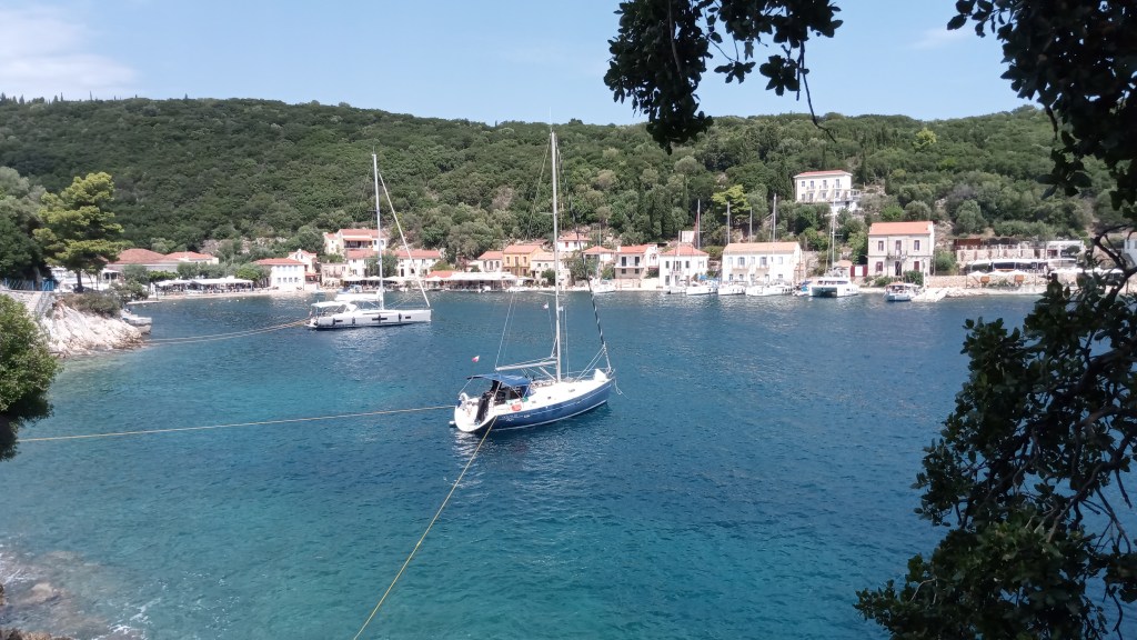
Kioni
Wednesday 13th September
On Sunday we sailed / motored to Vathi, the main town on Ithaca. It is at the head of a long inlet, very sheltered and with a huge anchorage as well as about half a kilometre of quay. When we arrived it was almost deserted but speaking to a chap who had been anchored there for a week, he said that a few days earlier there had been more that 300 boats in. Like most places in this region it was almost completely destroyed in the 1953 earthquake and has been rebuilt since in the same style of Venetian like architecture.
On Monday we sailed out of the bay in a fresh breeze but by the time we reached open sea it had faded away and so we motored and pulled into a bay called Paralia Filiatro. In the afternoon a light breeze filled in from SE and we beat down to the southern end of Ithaca at about 4kts in 8kts of wind. There was a fair swell from SE as we turned the corner and headed west across to Kefalonia. It was getting late when we pulled into Agia Eufimia and were lucky to get one of the last remaining spaces on the quay, wedged between two 45’ cats.
Yesterday we left Eufimia late morning as there was virtually no wind at all and we planned to meet up with Sammy in, believe it or not, the nearby port of Sami. En route we had another lunchtime stop and swim at Paliouras Beach. At Sami we were too late to be given a space inside the harbour and had to moor stern to on the outside of the quay. It was fairly bouncy during the evening but settled down by nightfall. It was a better deal at Sami than Eufimia, just €10 and unlimited fresh water.
Today we sailed out of Kolpos Samis bay and south toward the bottom of Kefalonia. At first we had a good breeze and I thought we might be able to make it to Zakinthos in one go but by lunchtime the wind was dying so we stopped for lunch and swim in Koutsoupia Bay. It’s a another bright white pebble beach. For a brief time we had the beach all to ourselves before a trip boat roared in and discharged its load of passengers. Tonight we are in Poros harbour, tied alongside a pontoon for the first time in a while. This I do prefer normally except that on Navilly there are reports of rats boarding boats so hatches will need to be firmly shut tonight.
10 minutes later !
Saturday 16th September
On Thursday we departed Poros just as a morning breeze filled in from NE, but within an hour it had vanished. As we reached the southern tip of Kefalonia, the forecast wind from W, between the islands, started to fill and by half way across the channel we had a fetch with 14kts and one reef in. We touched 7kts speed at one point and so arrived at Agios Nikolaos soon after 1500. It’s a natural harbour on the north east corner of Zakinthos, with an island providing some protection from easterlies. There is a quay wrapping around much of the bay and a lot of trip boats coming and going. We were directed to berth stern to in a gap only just wide enough for us but I do prefer to be wedged in as it limits problems from a cross wind. The following day Amanda returned home and I prepared for the start of the final leg of my five year odyssey to reach the Aegean. I shall be going around the bottom of the Peloponnese rather than through the Corinth Canal. Today the forecast is for a good breeze from NW by afternoon. So rather than take the direct route south down the east side of Zakinthos I decide to do a little detour and go around the top and down the west side. The wind will be better here and it has the more spectacular coastline including the famous Shipwreck bay. I cleared the harbour at noon with just enough wind to sail. There are dozens of trip boats going flat out to and from the caves around the northern cliffs. I stay offshore to keep clear and catch the wind, but instead of it coming from NW it bends around the top to settle on SW, so it’s a beat for most of the way to Shipwreck bay. Here I roll up the genoa and motor in as far as I dare given the very choppy water and onshore breeze, mixed up with trip boats crossing in all directions. Landing is prohibited. Then it’s onward south with the wind now coming around to a broad reach. It gradually builds as I run past tiny coves backed by towering cliffs. No possibility of safely anchoring for the night in any as they are either too deep or full of rocks that would snag the anchor. Toward the southern end the wind reaches 20kts and I hit 8.8 kts of boat speed surfing down waves. I then turn east around the bottom of the island and up into Lagana bay and the anchorage at Keri. This is the only part of the bay where anchoring is permitted as the whole area is a reserve to protect the turtles.
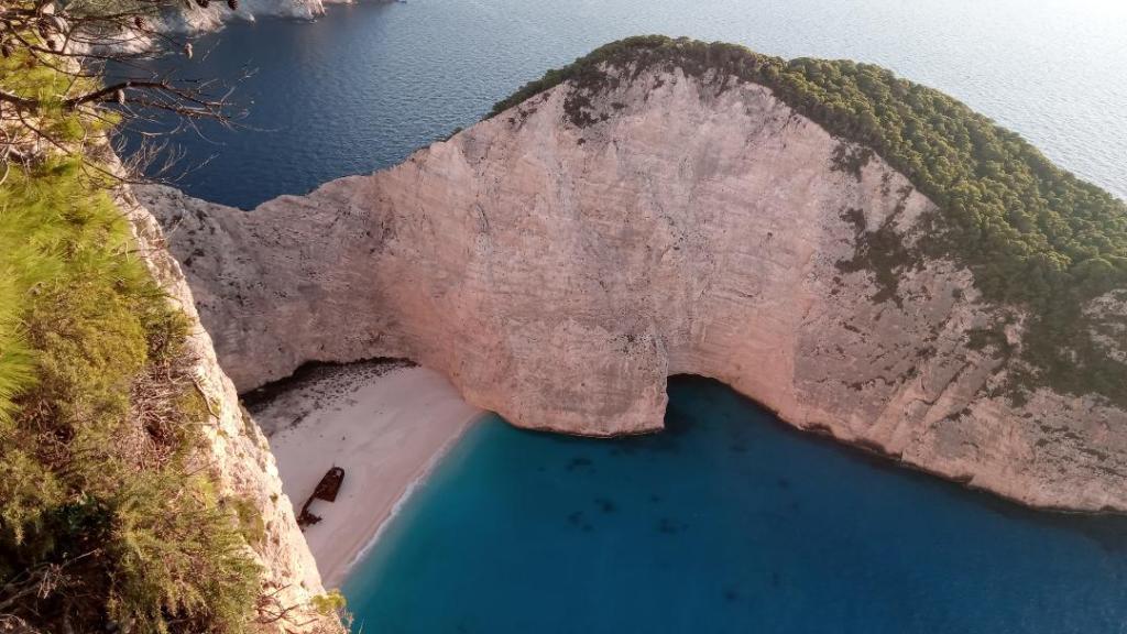
shipwreck bay from above…. and the next day at sea level

Thursday 21st September
Departed the anchorage at Keri last Sunday at 10.30 and crossed the bay close by the island of Marathonisi. It is supposed to be in a zone where boats are not permitted at all but it was surrounded by trip boats and even people landing on the beach. No sign of any turtles unsurprisingly. It’s a straight line due east across to Katakolon on the mainland. I was carried across on a broad reach with 10 to 15 kts from NW. The anchorage is large, just outside the harbour, with good holding on mud and sand. This is good as the next day I planned to visit Olympia. As it turned out, I postponed the trip to Olympia to Tuesday as on Monday three cruise ships came into the harbour. It was still very busy the next day as another ship came in. A small train runs the 25miles to Olympia, just the one there and back a day. The cruise passengers all go by coaches thank goodness.
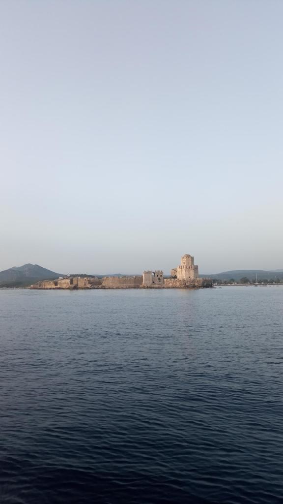
Next day I set sail for Kyparissia in a light offshore breeze. A couple of miles offshore I was approached by a small motorboat, the sort people hire for a day. When it was just a boat length away a man stood up, stark naked, and waved at me. I tried to ignore him and he carried on alongside for another 5 minutes trying to attract my attention before eventually giving up. Seriously weird. The breeze filled in so I carried on another 10 miles to an anchorage on the east side of Proti island. Vourlia Bay has an old wreck in the centre so I had to be careful to avoid swinging onto it. Yesterday I weighed anchor early to catch a land breeze taking me south to Pylos and the gulf of Navarinou. Here in the mid 1800s a small British naval fleet defeated a much larger Turkish fleet and effectively secured Greek independence from Turkey in that part of Greece. The locals were so grateful they erected a statue to the British commander, Admiral Codrington, and the owner of the marine shop in Pylos gave me a free bottle of extra virgin olive oil when I told him I was from England ! Later in the day I decided to move on a few more miles to the ancient port of Methoni, upon recommendation from my neighbour on the quay. Arriving just before sunset, the huge Ottoman castle glowed in the light.
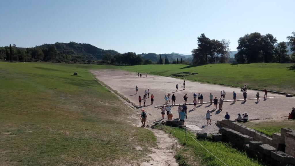
Olympia. The running track 197m from start line to finish line.
Methoni fortress
Saturday 23rd September
It has been and continues to be a regular pattern with the wind, nothing or just a little land breeze till mid morning, then nothing till early to mid afternoon when a sea breeze from W or NW gradually rises to a peak around 6pm, then gone by sun down. Yesterday I set off at midday heading around Cape Akritas, the first of the three toes that stick out of the bottom of the Peloponnesus that I will round. It turned out to be a fine run in 10 to 15 kts . The coastline is one of crumbling sedimentary mud, sands and gravels with off lying rocks and islands. Plenty of fine anchorages in small bays and little habitation. Not many boats now, in fact when I get to Koroni, just around the Cape, I am the only boat anchored. I might have stayed longer in the area but I have had a dead starter battery now for a few days and the only place to get a new one is going to be Kalamata. So today I left Koroni at about 1300, as the wind filled in, for the 15 nm passage across the Gulf of Messina to Kalamata. It has been another easy broad reach in 10kts on flat water. I didn’t see another boat, a sign of how much things have changed in just a week. I’m now well away from the waters frequented by charter boats, and the season is rapidly ending. The cafes in Koroni were almost empty of tourists. As I approached Kalamata I called up the Port to request a berth and received a very helpful response in English. The commercial port is now hardly used by shipping and there are miles of unused quay. There is a marina next door but why pay their fees when all I need is somewhere to tie up. On Navilly the Port is recommended, although the distance between bollards is designed for ships, so long lines are required.
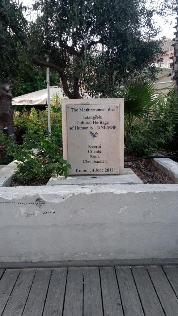
For a few years now I have been an advocate of the Mediterranean diet. I had no idea it had official designation !!
Tuesday 26th September
With a new starter battery sorted, full water tanks and a full larder, courtesy of Lidl, it’s time to move on. Two days ago the Port Police paid us a call so I had to visit their office and get the Transit Log stamped. This was the first time since Corfu, nowhere since has shown any interest. It meant I also had to visit again this morning to get a departure stamp. The forecast promised around 5 to 10kts from SW from midday but sadly it did not materialise until 1400 when I was just 8nm from my destination Limeni bay. There are very few good anchorages around the middle toe of the Peloponnesus, it is a rocky and exposed coastline, about as remote as it can get for mainland Greece. High mountains cause katabatic winds and there is a noticeable increase in swell. This wide bay extends well inland providing shelter except from west, and has a gently shelving sandy bottom with supposed good holding. The downside is that it is very swelly. This whole peninsular was the preserve of the Maniots in times gone by, fiercely independent people and a part of Greece that the Ottomans never ruled. The stone buildings have a particularly unique and attractive appearance. They were also known for their taste for piracy; as I’ll be awake all night anyway, due to rolling, I can keep a good lookout.

Kitties point, Kalamata in background
Friday 29th September
On Tuesday evening in Limeni bay I rigged up the kedge with 10m chain, then 30m multiplait anchor line, then 30m of mooring line and paddled it all as far as I could go toward the beach and set it. For once it worked a treat and held the boat head to the swell all night when the wind died away. In the morning there was a light land breeze so the kedge was now holding the stern into the wind. The forecast was for it to increase dramatically, so much so that I had decided to stay put for the day. I put a fender onto the kedge line before releasing it from the stern, which allowed the boat to swing around 180 and sit head to wind on the main anchor. I can recover the kedge when I come to leave the anchorage. It was then a rough day with thunderstorms and F6/7 winds, four other boats came in to shelter during the day. Thursday I made an early start with the aim of reaching Gytheion, at the head of the Gulf of Lakonika and a distance of over 40 miles. With a forecast steady F4 from east it might be doable. But it was slow progress especially past the towering cliffs of Capo Grosso, rising over 800 feet and peppered with caves where pirates hid their booty. One huge cave was considered in ancient times to be the entrance to Hades, the underworld. Rounding the middle toe, Ak Tainaron, was achieved without fuss and it was then a 180 turn up the east side of the Mani peninsular. Late afternoon, with no wind, I pulled into the aptly named Storm Cove just off the entrance to Ormos Skoutari, about 6nm short of Gytheion. I anchored dead centre of this small idyllic cove which meant that a little later when a large Sunseeker came in looking to drop his hook, there really was no place to safely do so without risking of us swinging into each other. He reluctantly gave up after half an hour of trying. Friday I covered the last few miles to Gytheion and anchored just outside the harbour, under Kranai island, where in the Iliad Paris and Helen spent their first night after eloping.

the desolate Cap Tainaron, the middle toe.
Monday 2nd October
Whilst in Gytheion I visited nearby Sparti, the modern town that sits on top of ancient Sparta, one of the great Greek polis states, and who’s people were famous as fearsome warriors. They’ve toned it down these days but still hold athletes in very high regard.
The days are noticeably shorter than a month ago, there are just about 12 hours of useable daylight. So I am trying to position myself for the passage from the Peloponnesus to the nearest of the Cyclades islands, Mylos. It is a distance of 60nm from land to land but in reality the nearest departure point is an anchorage on Elafonisos island, adding a further 15 miles. It is therefore going to have to be a night passage to be sure of an arrival in daylight. An added complication is we have very strong winds (the meltemi) forecast for a couple of days, making the anchorage there untenable. So the plan is to go to Plytra, across the Gulf, to hunker down before setting off on a non stop passage to Mylos, hopefully clearing Cap Maleas (the third and biggest toe) just as the winds are moderating. Light winds from various directions have carried me the 16nm across the Gulf to Xylis Bay and the small village of Plytra at its head. This is an excellent anchorage, with a half mile wide sandy bay that gives good holding and low lying ground to north from where the winds will come, so no katabatic effect.
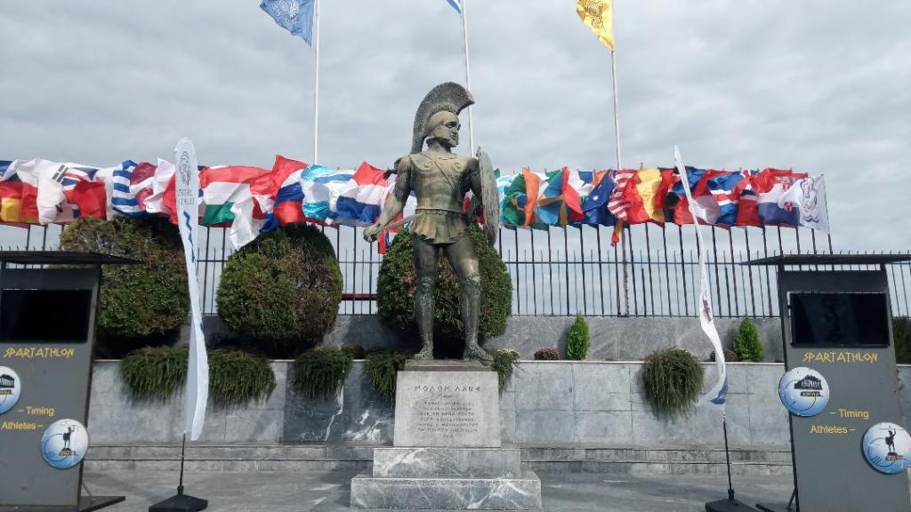
the classic Spartan warrior
